![](/images/other/stat-length.png)
![Tocht Stappen Centro Valle Intelvi - mont generoso - Photo](https://media.geolcdn.com/t/1900/400/ext.pjpeg?maxdim=2&url=https%3A%2F%2Fservices.sitytrail.com%2FGeolivesWS%2FDownloadMedia.ashx%3FTrailID%3D335511%26Media%3Dfix__20140816124511.jpg)
mont generoso
herve.feurprier
Gebruiker
![Lengte](/images/other/stat-length.png)
Lengte
13,2 km
![Max. hoogte](https://static1.geolcdn.com/siteimages/upload/files/1508320355ic_sort_altitude_max_24dp.png)
Max. hoogte
1628 m
![Positief hoogteverschil](https://static1.geolcdn.com/siteimages/upload/files/1508320355ic_sort_den_pos_24dp.png)
Positief hoogteverschil
682 m
![Km-Effort](/images/other/stat-length.png)
Km-Effort
22 km
![Min. hoogte](https://static1.geolcdn.com/siteimages/upload/files/1508320355ic_sort_altitude_min_24dp.png)
Min. hoogte
1048 m
![Negatief hoogteverschil](https://static1.geolcdn.com/siteimages/upload/files/1508320355ic_sort_den_neg_24dp.png)
Negatief hoogteverschil
692 m
![Boucle](https://static1.geolcdn.com/siteimages/upload/files/16400158638029165_repeat_loop_refresh_sync_direction_icon.png)
Boucle
Ja
Datum van aanmaak :
2019-05-18 00:54:46.25
Laatste wijziging :
2019-05-18 00:54:47.856
![Stappen](https://static1.geolcdn.com/sitytour/trail-icons/101.png)
4h46
Moeilijkheid : Medium
![Scan deze QR-code om de tocht te openen in de SityTrail-applicatie](https://capi.geolives.com/qq0zvz2zws4bq2lad0pu/sitytour/trails/335511/qr.png?size=200)
Gratisgps-wandelapplicatie
Over ons
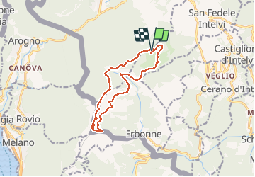
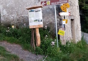
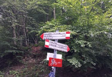
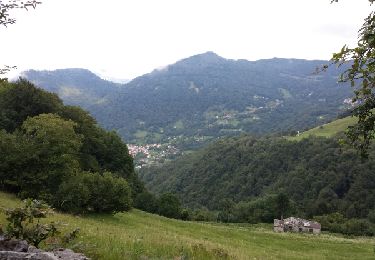
Tocht Stappen van 13,2 km beschikbaar op Lombardije, Como, Centro Valle Intelvi. Deze tocht wordt voorgesteld door herve.feurprier.
Beschrijving
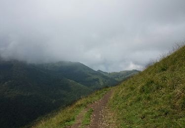
Très belle randonnée jusqu'au sommet du Mt Géneroso avec des panoramas magnifiques sur 360°.A faire absolument !
Plaatsbepaling
Land:
Italy
Regio :
Lombardije
Departement/Provincie :
Como
Gemeente :
Centro Valle Intelvi
Locatie:
Unknown
Vertrek:(Dec)
Vertrek:(UTM)
503765 ; 5089191 (32T) N.
Opmerkingen
Wandeltochten in de omgeving
![Tocht Te voet Centro Valle Intelvi - Monte Generoso-Crocette - Photo](https://media.geolcdn.com/t/375/260/c8254049-1752-403a-8fe3-53196ebeb59b.jpeg&format=jpg&maxdim=2)
![Te voet Te voet](https://static1.geolcdn.com/sitytour/trail-icons/100.png)
Monte Generoso-Crocette
Te voet
Gemakkelijk
Centro Valle Intelvi,
Lombardije,
Como,
Italy
![](/images/other/stat-length.png)
8 km | 11,6 km-effort
2h 38min
![](https://static1.geolcdn.com/siteimages/upload/files/16400158638029165_repeat_loop_refresh_sync_direction_icon.png)
Neen
![Tocht Stappen Schignano - sentiero espressioni - Photo](https://media.geolcdn.com/t/375/260/ext.jpg?maxdim=2&url=https%3A%2F%2Fservices.sitytrail.com%2FGeolivesWS%2FDownloadMedia.ashx%3FTrailID%3D853798%26Media%3Dfix__20170806210244.jpg)
![Stappen Stappen](https://static1.geolcdn.com/sitytour/trail-icons/101.png)
sentiero espressioni
Stappen
Medium
Schignano,
Lombardije,
Como,
Italy
![](/images/other/stat-length.png)
17,6 km | 30 km-effort
6h 27min
![](https://static1.geolcdn.com/siteimages/upload/files/16400158638029165_repeat_loop_refresh_sync_direction_icon.png)
Ja
![Tocht Stappen Centro Valle Intelvi - Pizza della Croce - Photo](https://media.geolcdn.com/t/375/260/ext.jpg?maxdim=2&url=https%3A%2F%2Fservices.sitytrail.com%2FGeolivesWS%2FDownloadMedia.ashx%3FTrailID%3D340011%26Media%3Dfix__20140828122813.jpg)
![Stappen Stappen](https://static1.geolcdn.com/sitytour/trail-icons/101.png)
Pizza della Croce
Stappen
Heel gemakkelijk
Centro Valle Intelvi,
Lombardije,
Como,
Italy
![](/images/other/stat-length.png)
5,9 km | 9,2 km-effort
2h 0min
![](https://static1.geolcdn.com/siteimages/upload/files/16400158638029165_repeat_loop_refresh_sync_direction_icon.png)
Ja
![Tocht Stappen Schignano - la concassées di schignano - Photo](https://media.geolcdn.com/t/375/260/ext.jpg?maxdim=2&url=https%3A%2F%2Fservices.sitytrail.com%2FGeolivesWS%2FDownloadMedia.ashx%3FTrailID%3D338021%26Media%3Dfix__20140822164834.jpg)
![Stappen Stappen](https://static1.geolcdn.com/sitytour/trail-icons/101.png)
la concassées di schignano
Stappen
Gemakkelijk
Schignano,
Lombardije,
Como,
Italy
![](/images/other/stat-length.png)
9,3 km | 17,1 km-effort
3h 28min
![](https://static1.geolcdn.com/siteimages/upload/files/16400158638029165_repeat_loop_refresh_sync_direction_icon.png)
Ja
![Tocht Stappen Cerano d'Intelvi - San zeno - Photo](https://media.geolcdn.com/t/375/260/ext.jpg?maxdim=2&url=https%3A%2F%2Fservices.sitytrail.com%2FGeolivesWS%2FDownloadMedia.ashx%3FTrailID%3D336950%26Media%3Dfix__20140819180535.jpg)
![Stappen Stappen](https://static1.geolcdn.com/sitytour/trail-icons/101.png)
San zeno
Stappen
Medium
Cerano d'Intelvi,
Lombardije,
Como,
Italy
![](/images/other/stat-length.png)
9,9 km | 16,7 km-effort
3h 28min
![](https://static1.geolcdn.com/siteimages/upload/files/16400158638029165_repeat_loop_refresh_sync_direction_icon.png)
Ja
![Tocht Te voet Cerano d'Intelvi - (SI D11N) Rifugio Prabello - Rifugio Boffalora - Photo](https://media.geolcdn.com/t/375/260/ext.jpg?maxdim=2&url=https%3A%2F%2Fstatic1.geolcdn.com%2Fsiteimages%2Fupload%2Ffiles%2F1545311037marcheuse_200dpi.jpg)
![Te voet Te voet](https://static1.geolcdn.com/sitytour/trail-icons/100.png)
(SI D11N) Rifugio Prabello - Rifugio Boffalora
Te voet
Zeer moeilijk
Cerano d'Intelvi,
Lombardije,
Como,
Italy
![](/images/other/stat-length.png)
26 km | 43 km-effort
9h 42min
![](https://static1.geolcdn.com/siteimages/upload/files/16400158638029165_repeat_loop_refresh_sync_direction_icon.png)
Neen
![Tocht Mountainbike Cerano d'Intelvi - Val d'Intelvi - Photo](https://media.geolcdn.com/t/375/260/ext.jpg?maxdim=2&url=https%3A%2F%2Fstatic1.geolcdn.com%2Fsiteimages%2Fupload%2Ffiles%2F1524743154velo.jpg)
![Mountainbike Mountainbike](https://static1.geolcdn.com/sitytour/trail-icons/202.png)
Val d'Intelvi
Mountainbike
Medium
Cerano d'Intelvi,
Lombardije,
Como,
Italy
![](/images/other/stat-length.png)
26 km | 40 km-effort
3h 41min
![](https://static1.geolcdn.com/siteimages/upload/files/16400158638029165_repeat_loop_refresh_sync_direction_icon.png)
Ja
![Tocht Stappen Breggia - Valle di Muggio - Photo](https://media.geolcdn.com/t/375/260/ext.jpg?maxdim=2&url=https%3A%2F%2Fstatic1.geolcdn.com%2Fsiteimages%2Fupload%2Ffiles%2F1553511878bg_sport_marche.png)
![Stappen Stappen](https://static1.geolcdn.com/sitytour/trail-icons/101.png)
Valle di Muggio
Stappen
Heel gemakkelijk
Breggia,
Ticino,
Distretto di Mendrisio,
Switzerland
![](/images/other/stat-length.png)
6,2 km | 13,5 km-effort
Onbekend
![](https://static1.geolcdn.com/siteimages/upload/files/16400158638029165_repeat_loop_refresh_sync_direction_icon.png)
Ja
![Tocht Stappen Centro Valle Intelvi - San Fedele - Photo](https://media.geolcdn.com/t/375/260/ext.jpg?maxdim=2&url=https%3A%2F%2Fstatic1.geolcdn.com%2Fsiteimages%2Fupload%2Ffiles%2F1553511878bg_sport_marche.png)
![Stappen Stappen](https://static1.geolcdn.com/sitytour/trail-icons/101.png)
San Fedele
Stappen
Medium
Centro Valle Intelvi,
Lombardije,
Como,
Italy
![](/images/other/stat-length.png)
14,1 km | 24 km-effort
3h 31min
![](https://static1.geolcdn.com/siteimages/upload/files/16400158638029165_repeat_loop_refresh_sync_direction_icon.png)
Neen